First in a series about the Inca Trail

The Inca Trail to Machu Picchu is one of the world’s great hikes. At 43 km (26.7 mi), the route is coincidentally similar in distance to a marathon, but hikers spend three and a half days completing it. The Peruvian government has balanced the high demand with the need to minimize damage to the ancient trail by requiring all hikers to be guided by an accredited tour operator. Only 500 permits per day are authorized, at an approximate ratio of two hikers for every three support personnel (porters, guides, cooks). Tours sell out months in advance. Rachel and I booked with Peru Treks back in December 2014 based on solid reviews and commitment to fair treatment of its porters. Permits for the popular dry season (winter in the Southern Hemisphere) go on sale early in the year; in February, Peru Treks confirmed they had purchased our permits.

The Toughest Hike
Hiking the Inca Trail was one of the most memorable experiences in my life. I also admit that I was caught off guard by the sheer difficulty of the hike. Though I’m no backpacker, I’ve held my own during fairly lengthy day hikes in the mountains of Oregon, Montana, and Canada. My wife Rachel grew up tackling 50-mile hikes in the High Sierra and climbed the 4,421 m (14,505 ft) Mt. Whitney three times, but she agreed that this was the toughest hike of her career.
Certainly, I anticipated that the altitude of the Inca Trail could be an issue. It ranges from 2,430 m (7,972 ft) at the lowest point (Machu Picchu itself, ironically enough) to a high point of 4,215 m (13,829 ft) at the sinisterly named Dead Woman Pass. With that in mind, I planned to start the hike near the end of the trip, allowing us to spend eight days above 3,000 m for acclimation purposes. At one point I’d entertained the prospect of a trip to Acadia National Park earlier in the summer to train for mountainous terrain, at least as much as is possible on the Eastern Seaboard.
As it turned out, we spent practically every free minute during the months leading up to our departure scurrying around to get ready for our wedding. There wasn’t even time to train locally for the hike, not that anything in flat-as-a-board, nearly sea level Delaware offers an analogue for hiking through the Andes. Still, even with a heavy backpack and the altitude, I wasn’t overly concerned. After all, we had all day to hike distances that (except for the short fourth day) varied between 11 km and 15 km per day (6.8 mi to 9.3 mi).
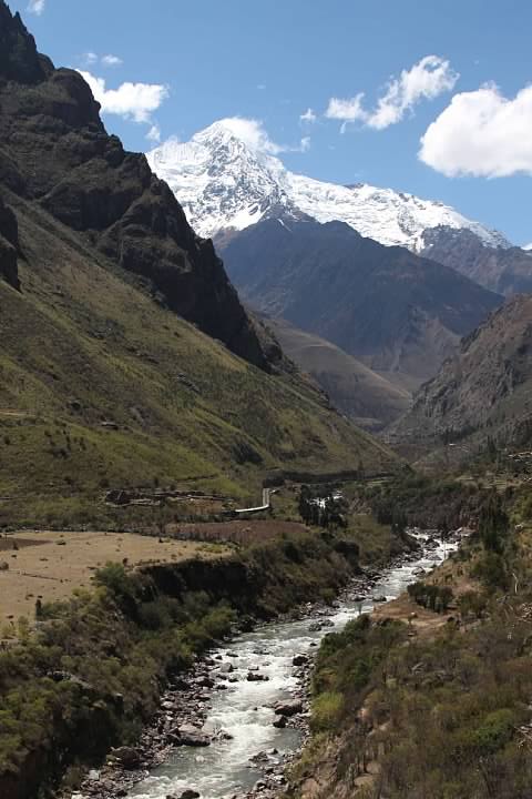
As it turns out, the terrain combined with the altitude was draining. According to our guides, the Inca Trail passes through seven distinct ecosystems, separated by elevation and mountain passes. From lunchtime on the Day One onward, practically every step was either up or down. Indeed, after the easy first few opening kilometers, there probably wasn’t a single stretch of trail more than 30 m (98 ft) long that was completely flat. Even as I struggled for breath on the grueling sections like the steep ascent to Dead Woman Pass on Day Two, or the steep stairs nicknamed “The Gringo Killer” on Day Three, I knew that the hike was not nearly as difficult as it could have been. After all, the Peru Treks support staff were not only carrying all the food and tents, but also setting the tents up and doing the cooking. It was deeply humbling to realize how much I’d underestimated the terrain and overestimated my physical condition.
Perhaps I should mention that this particular trail was designed for pilgrimage, not sheer practicality. Despite being referred to as Inca Trail in numerous sources (including this one, for simplicity), the Inca Trail in question is just one of many trails in the area built by the Incas. At several points during our hike, other trails were visible. Our guides identified them as commercial and military trails. The commercial trail had a much flatter profile; our guide said that a hiker could reach Machu Picchu from the same starting point in Piscacucho after just eight hours of hiking rather than three plus days on the initially nearby Inca Trail. The Inca Trail, it seems, was not designed to be the easiest or most practical connection between two places, but instead to bring pilgrims in contact with the mountains and rivers that the Inca deemed sacred.

Packing for the Inca Trail
Prior to the start of the trip, Rachel had supplied us with two old Kelty external frame backpacks: one that she’d used during hikes in her youth and another that had belonged to her brother. External frame backpacks had gone out of style circa 1990, presumably with good reasons. Still, other than their absurdly retro appearance, I could not articulate a reason not to use them. Sticker shock from the more modern backpacks on display at Eastern Mountain Sports sealed the deal: retro it would be.
The night before our departure, we began sorting out what to bring on the trail and what leave in storage at our hotel. (Most Cusco hotels will store your belongings if you’re coming back to the same one at the end of the trek.) Despite being an unabashed shutter bug, I wasn’t thrilled with lugging the weight of all my cameras the entire time. Having never seen any infrared photographs of Machu Picchu before, however, I couldn’t bear to leave it back at the hotel. (Not to get anyone’s hopes up, since Machu Picchu didn’t end up looking as spectacular in infrared as I’d hoped.)

If the external frame backpack wasn’t unfashionable enough, being a shutter bug was about to cost me a little more dignity as well. My usual camera bag, a Lowepro SlingShot, would be impractical combined with the Kelty backpack unless I wanted to carry the Lowepro on my front the entire trek. I also didn’t want the camera hanging from my neck all day.
After some research online, I settled on a camera vest by Cotton Carrier. A mounting bracket attaches to the camera’s tripod thread. The camera is mounted on the vest facing down, close to the wearer’s chest and is quite secure from any movements by the wearer. Rotating the camera a quarter turn makes it possible to remove the camera from the vest.
Style notwithstanding, the vest served its purpose perfectly. The camera feels weightless when sitting on the vest and the vest fit comfortably with the backpack. The camera can be drawn and ready to shoot in about a second, even less time than it takes to draw from my SlingShot. That paid dividends a few times, such as Day Three when a hummingbird suddenly appeared about a meter in front of me, feeding on trailside flowers for just a few seconds.
I debated how many layers to bring. I ended up taking a fleece jacket, a light alpaca wool sweater, light raincoat and a winter coat shell. The winter coat was recommended by Peru Treks because the second night’s campsite is at fairly high altitude and rather chilly. During our particular trek the winter coat was unnecessary, heavy, and space consuming, but it also probably would have been risky to hike without it. The weather for the trek was perfect: warm and sunny except for a rain shower while we were in camp the evening of Day Two. Had the weather been different, the winter coat could have been lifesaving. I also probably could have left the sweater or fleece jacket and used the raincoat as an additional layer.
Rachel was skeptical about my decision to pack a backup pair of shoes. I wanted to have a shoe with ankle support for the steep portions but a more comfortable low rise shoe for the easier portions. Furthermore, in college I had the experience of spending a weekend in wet boots during an adventure because I didn’t have a spare pair. Afterward I had tingling in one toe for months. Never again. As it turned out, my boots didn’t get wet on the trek, but I was happy I had a spare set of shoes after I got painful blisters from descending the 1,500+ steps known as “The Gringo Killer” on Day Three. The other shoes didn’t rub the same way, after all, and with some Moleskin I was perfectly comfortable on Day Four.

Early Start
We had the good fortune to have the earliest pickup time of the sixteen hikers in our group. We were told to expect pickup from 4:30 am to 5:00 am at our hotel, the Hotel Rumi Punku. The Peru Treks bus arrived around 4:50 am. The bus made its rounds through the colonial streets of Cusco picking up the different hikers and then headed up the hill out of town. Our guides introduced themselves as Percy and Yaneth (Janet). Both spoke excellent if heavily accented English. They eschewed the bright yellow uniform shirts worn by the Peru Treks porters for nondescript clothes.
Percy had a casual vibe and wry smile. He habitually addressed the group as, “My friends” (usually every sentence!). Yaneth addressed us not as friends but as “family” or “brothers and sisters”. She introduced herself as the youngest guide on the trail. The small backpack she hiked with was decorated with cute keychain stuffed animals.

Most of the hikers dozed off during the roughly 90 minute bus ride, but I sat captivated by the snowcapped peaks of the Andes’ Urubamba Range glowing yellow in the early morning sun. The road made a torturous, windy descent into the Sacred Valley at the town of Urupampa (Urubamba). The bus continued through the valley to the town of Ollantaytambo, stopping in the main square, the Plaza de Armas around 7 am. The town of Ollantaytambo was originally built by the Incas. There are extensive ruins on the steep hillsides surrounding the town.
We joined other hikers in our group for breakfast at a restaurant facing the plaza that Percy had recommended. The menu appeared designed to cater exclusively to foreign tastes, but omelets and banana pancakes were perfect food for the trail. The plaza was filled with local women hawking hiking wares. Rachel bought a telescoping hiking pole for 20 soles (about $6). The women then fixated on me, trying to sell me any and all hiking trinkets despite Rachel’s assurances in Spanish that I had all I needed.
After the breakfast stop, we clamored back onto the bus a little after 8 am for the remaining ride to the trailhead for our hike at Piscacucho.
Series on the Inca Trail (Camino Inka)
Planning a Trip to Bolivia and Peru (background)
Introduction (Cusco to Ollantaytambo by Bus)
Day One (Piscacucho to Wayllabamba)
12 km (7.5 mi) distance, +300 m (984 ft) elevation
Day Two (Wayllabamba to Pacamayo)
11 km (6.8 mi) distance, +1,200 m (3,937 ft)/-600 m (1,969 ft) elevation
Day Three (Part I, Pacamayo to Qunchamarka AND Part II, Chaquicocha to Wiñay Wayna)
15 km (9.3 mi) distance, +350 m (1,148 ft)/-13,00 m (4,265 ft) elevation
Day Four (Wiñay Wayna to Machu Picchu)
5 km (3.1 mi) distance, +40 m (131 ft)/-265 m (869 ft) elevation
Inca Trail’s End: Machu Picchu
