
Second in a series about the Inca Trail
After our trekking group ate breakfast in Ollantaytambo, we boarded the bus for the short ride to Piscacucho, also referred to as Km 82 on signs and reference maps, arriving around 9:15 am. A hiker could be forgiven for thinking that a sign welcoming them to the Camino Inka at Km 82 meant that they were at Km 82 of the trail itself (with Machu Picchu presumably at Km 0). The Inca Trail isn’t quite that long. The kilometer designation actually refers to the location along the rail line between Cusco and Aguas Calientes (the town below the heights of Machu Picchu). This rail line is vital for the vast majority of visitors to Machu Picchu who do not hike the Inca Trail, because Aguas Calientes does not have road connections to the outside world.
Piscacucho is as far as the road goes, making it a natural starting point for treks. Alexander Stewart’s guidebook The Inca Trail indicates that an alternative is to start at Km 88, traveling via railroad. The spurs from Km 82 and Km 88 eventually merge together. I consulted various references in an attempt to determine if one or the other is the “true” start of the Inca Trail but eventually gave up. It seems “your mileage may vary” quite literally on the Inca Trail, since there are a few variant routes.
Update on December 17, 2015: In a book I read recently (Machu Picchu: Exploring an Ancient Sacred Center), American archaeologist and anthropologist Johan Reinhard indicates the Inca Trail to Machu Picchu starts at Patallaqta, the settlement mentioned below. That makes sense given that the spur trails meet near there, and considering the character of the trail from Km 82 to Patallaqta is completely different than the rest of the trail.

A Note About Names
Trying to keep the names of things on the Inca Trail straight can be a frustrating exercise. Quechua, the language of the Incan Empire, originally had no written form. Sometimes a place’s Spanish name is based on Hispanicizing the original Quechua, sometimes not. Lately, there seems to be a trend to bring the Quechua place names back. Of course, that means deciding which version to use since until recently there was no orthographic convention. Take the beautiful snowcapped mountain known in Spanish as Nevado Verónica. According to Wikipedia, the mountain’s name in Quechua is Willka Wiqi, or “holy tear”. Or, if you prefer, “Waqrawillk’i, Waqaywillk’i, Waynawillka, Waqaywillka or Waqaywillkay”.
There also seems to be some variation in whether certain words are rendered with a W or H. For instance, Huayna Picchu and Wayna Picchu are the same mountain.
I was surprised to learn that nobody knows what the Incan city now referred to as Machu Picchu was actually called. Machu Picchu actually refers to the name of the mountain the city is built upon. Since the Incans didn’t keep written records, the Spaniards apparently didn’t know about it, and no oral tradition about the city survives, the city’s true name will likely remain a mystery forever. Since everything needs a name, many sites along the Inca Trail had Quechua names bestowed upon them by archeologists, describing their location or, in one case, an orchid that grows near the ruins!
Update on December 17, 2015: According to Peruvian archaeologist Lucy C. Salazar (specifically her essay in Machu Picchu: Unveiling the Mystery of the Incas), the proper term to refer to Machu Picchu is “royal estate”, not city. I will discuss this further in my article about Machu Picchu itself.
In writing this series of articles, I decided to try to list one Quechua name (with Spanish name in parentheses if applicable). My satisfaction at coming up with this convention evaporated when I realized that it would break down by the very next paragraph when yet another language enters the mix (for the first and only time.) I beg the reader’s pardon for any errors I might make in this matter.

Crossing the Sacred River
In a parking lot above the rail line, we assembled our gear and put on sunscreen. It was a beautiful day for hiking: sunny and comfortably warm with low humidity. The railroad tracks ran parallel to the swiftly flowing river Willkanuta (río Vilcanota). Willkanuta (meaning “house of the sun”) is actually a name deriving from another native language, Aymara. The same river is called río Urubamba or Willkamayu (Quechua this time) downriver. The Quechua name means “Sacred River”. It’s no surprise that this is the river that carved the Sacred Valley of the Incas. The Inca Trail runs parallel to the river only briefly before the trail jogs to the south, but the river continues west/northwest, running through Aguas Calientes and past Machu Picchu.
Update on December 18, 2015: Reinhard provides some context for the otherwise puzzling Aymara name for the river, writing that, “According to current-day beliefs the sun follows the course of the Vilcanota River underground during the night to rise again the next day in the east.”

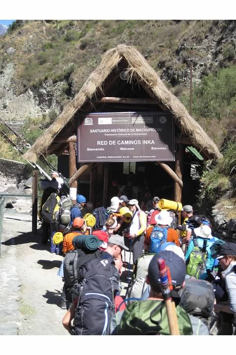
Percy had us assemble on the far side of the railroad tracks for the obligatory group photo in front of the “Camino Inka-Inka Trail” sign that welcomed us the Santuario Histórico de Machupicchu.

Afterwards, we walked a short distance to line up at the checkpoint located next to a footbridge spanning the river. It was the first of four checkpoints we’d pass through on the trail. Percy gave us the original permits to present at the post. The warden examined our permits and passports and stamped the back of the permit. (The permits were initially collected but must have been returned to the guides because we got them back on Day Four.)
Reportedly, the porters’ packs are also weighed at these posts to make sure they’re not over 20 kg (44 lbs). It seems some less scrupulous trekking companies circumvent this process by having hikers carry their own packs through the post but then give them to the porters afterwards. On the remainder of the trek we saw several groups where the hikers had just day packs or no backpacks at all, though this might have also been the result of them having hired a personal porter for the toughest day.
- Warden’s post

I was intrigued to see a man walking a motorcycle or dirt bike across the footbridge, since I didn’t see any mechanized traffic the rest of the trek. There were pack animals on the trail during the first two days of the trek. Although I had pictured the Inca Trail as being exceedingly isolated, as a matter of fact there were regular settlements along the Inca Trail at the start of the trek. Peru Treks actually didn’t provide water until we had passed the settlements; we had to buy it at trailside stores. Prices increased as we got further and further from the trailhead. The first bottle of water I purchased cost 4 soles (about $1.25), while the last was 10 (and I heard the prices went even higher later on).

Rachel and I passed through the checkpoint around 10:15am. After crossing the river, the group assembled at the top of a short hill. This viewpoint was the first of many, offering of the river as well as Willka Wiqi (Nevado Verónica) to the east. At 5,893m (19,334′), the mountain has a beautiful permanent mantle of ice and snow as implied by its Spanish name. We began to hike west along the river.
Update on December 17, 2015: Reinhard gives the mountain’s height as 5,750m (18,865) and discusses the etymology of the mountain’s name in greater detail. He states both Quechua words in the name mean “sacred object.” In addition, he writes:
“The Incas frequently applied the term uaca bilca (waqa willka) to local deities, especially mountains. It is also possible that the name derives from willki, meaning spirit of a ‘peak,’ and waqay, meaning ‘to cry.'”
Similarly, Wikipedia translates the name as “holy tear.” Reinhard explains that the tears in question refer to either the streams flowing from the mountain or the idea that the mountain controls rain. Reinhard says Willka Wiqi “is still highly revered by people in the region. It is worshipped for the fertility of crops, livestock, and good health.”

An Easy Start
Hiking the first few kilometers west of Km 82 trailhead was a completely different experience from the remaining three days of the trek. The early portion is a dirt path, considerably flatter and easier than the stone steps and constantly changing elevation that characterizes the rest of the trail. Our guide, Percy, indicated that while about 90% of the trail on Day Three is original to Incan times, a considerable portion of the trail on Days One and Two have been rebuilt.


At the start of the trail, the terrain was rocky and despite the proximity of the river, quite arid. A variety of species of cacti and other desert plants were visible at the side of the trail. Percy said this was the first of seven distinct ecosystems (one of my reference books says there are as many as ten) along the trail, all separated by changes in elevation and which side they were located on with regard to a series of three mountain passes. Desert on Day One, jungle on Day Three.


The Sacred Valley is filled with ruins. We didn’t learn anything about the first few sites we passed, but our guides went over subsequent archeological sites adjacent to the trail in great detail. After a few kilometers of flat terrain, the trail began to gain elevation fairly rapidly as we climbed the hills above the river. We got a good view of Willka Wiqi and the river before the mountain temporarily disappeared behind a closer mountain.

After a particularly steep segment, we arrived at the first settlement along the trail, where we stopped briefly for a break around noon. I believe the town is called Miskay or Meskay based on its labels on different maps. I topped off my water at one of the store huts.

Surprise on a Hilltop
After passing through the village, we took a fork in the trail to the left. (A trail also continued straight ahead. From the maps, it appears that this “road not taken” is considered a spur of the Inca Trail as well. It circles the base of a hill that we were about to climb and merges with the trail coming from the Km 88 trailhead. All the trails eventually came together at the base of the hill.)

The trail ascended a hill quite steeply. There were remnants of stone steps that would become quite familiar during the next two days of the trek.

Percy promised us there would be a surprise waiting for us at the top of the hill. He was right. The hill was quite flat on top with a cliff facing the confluence of the Willkanuta (the Sacred River, the one the trail has been paralleling thus far) and another smaller river, the Kusichaka (Cusichaca). Across the Kusichaka was an expansive ruin, the largest we’d seen yet.

This was the Incan settlement of Patallaqta (Llaqtapata). (It should not be confused with another place called Llaqtapata, a different Incan site within view of Machu Picchu. The name means “elevated settlement” or “settlement on a platform” which could describe many sites in the sanctuary. Seriously, Inca Trail names could drive someone insane.) The terraces served dual duty for erosion control and agriculture. According to Stewart’s The Inca Trail, evidence suggests the settlement’s main purpose was growing maize to feed other settlements in the region, but that its proximity to several Incan trails means it may have had a “strategic function” as well.

Given the commanding location of the viewpoint, it’s no surprise that there were the ruins of an Incan hillfort nearby, Willkaraqay (Huillca Raccay). From the viewpoint onward, the trail headed south, leaving the Sacred River to parallel the Kusichaka instead. We passed by the ruins of Willkaraqay as the trail headed downhill. Peru Treks and several other tour companies stopped for lunch in a town (labeled Tarachayoc or Tarayoq on my maps) along this new river at maybe 1:30 or 2 pm. Restrooms were available for a fee of 2 soles (about 60 cents). Kitchen and dining tents were already set up by the time the hikers arrived. As we dropped our packs a porter handed out glasses of juice or fruit flavored water.
I can only imagine the difficulty of cooking for sixteen hikers and twenty-some guides and porters in the field, but our cook Milton did fine work. It seemed every meal with better than the last, often with soup, rice, potatoes (a crop first cultivated in Peru), vegetables, and meat or poultry. This description is fairly vague because most meals (except for the best one, lunch on Day Three) I didn’t take notes or photographs and in my memory they blur together (even after just two weeks). After a hard day hiking, the vegetable or potato soup served during lunch or dinner hit the spot every time.

We got back on the trail just after 3 pm. I was surprised when Yaneth told the group to head south along the Kusichaka at our own pace with the guides following behind. Up to this point, generally one guide had been on point, setting the pace for the fastest hikers while one was acting as a sweep on the trail behind the stragglers. Yaneth said our pace would determine how early we had to get up the next day. It was a pleasant enough stroll uphill. Under these circumstances, the group spread out. For a lot of this section I couldn’t see any other hikers, including Rachel. (I know it was our honeymoon, but there were large spans when we found it too difficult to hike at one another’s pace!) It was slightly disconcerting to be alone on an unfamiliar trail, but there weren’t any forks in the trail to get lost on.

We arrived at Wayllabamba, the last major settlement on the Inca Trail (and our camping site for the night) around 4:45 pm. The village and our campsite were already in shadow but the mountain peaks surrounding the site caught the last light from the setting sun. The tents we would sleep in were already set up. (Over the course of the trek I had endless admiration for the way the support staff were choreographed, setting up and breaking down the camp and lunch sites and then rushing ahead to set up in advance of the party’s arrival at the next site.)

It was a relief to be able to change into a pair of Keen sandals and let my feet air out. There was a toilet with running water at at hut nearby. Like most lavatories on the trail, it was not terribly clean, but it had the distinction of being the last conventional toilet I saw until Aguas Calientes. From here on, it was squat toilets! In Peru, the sun sets early in August. While waiting for dinner, the hikers in the group talked while sitting on folding stools. For a time we put an electric lantern in the center of the circle (since no campfires are allowed in the sanctuary) but shut it off to save batteries and stargaze.
The night sky was very dark here and blazed with unfamiliar Southern Hemisphere stars. I’m sad to say this was the last night that the group really socialized together outside of mealtime; the next two days were far longer and more grueling and everyone went to sleep immediately after dinner.
Before we went to sleep, Percy warned us not to leave anything outside the tents overnight, especially shoes: Stray dogs in the area loved to steal them.
Date: Wednesday, August 19, 2015
Distance: 12 km (7.5 mi)
Steps recorded for the day: 24,659
Equipment: Kelty external frame backpack, Merrell Chameleon hiking shoes
Duration: About 6.5 hours (about 4.5-5 hours of that hiking)
Series on the Inca Trail (Camino Inka)
Planning a Trip to Bolivia and Peru (background)
Introduction (Cusco to Ollantaytambo by Bus)
Day One (Piscacucho to Wayllabamba)
12 km (7.5 mi) distance, +300 m (984 ft) elevation
Day Two (Wayllabamba to Pacamayo)
11 km (6.8 mi) distance, +1,200 m (3,937 ft)/-600 m (1,969 ft) elevation
Day Three (Part I, Pacamayo to Qunchamarka AND Part II, Chaquicocha to Wiñay Wayna)
15 km (9.3 mi) distance, +350 m (1,148 ft)/-1,300 m (4,265 ft) elevation
Day Four (Wiñay Wayna to Machu Picchu)
5 km (3.1 mi) distance, +40 m (131 ft)/-265 m (869 ft) elevation
Inca Trail’s End: Machu Picchu

[…] a more detailed description of the hiking terrain and other elements of the trek, I refer you to this blog, which I found and came to love as I was writing. The author really has some excellent comments and […]
LikeLike